SSA in Action: How Satellites Avoid Colliding With Each Other

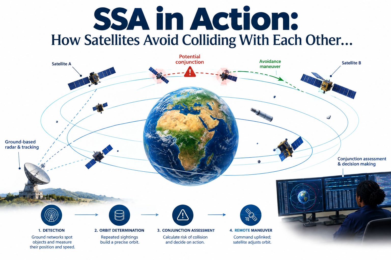
There are no traffic lights in orbit, so how does anyone know when two satellites are about to collide?
A Sky With No Traffic Rules
Anyone who has driven through a busy junction knows the basic idea of avoiding a collision. You see the other car coming, you judge its speed and you decide whether to slow down or keep going. Satellites face the same basic problem, except nobody up there can see anything with their own eyes and nobody can brake in the real sense. Each satellite is fixed moving along its orbit, the fixed path gravity forces it to follow around the Earth and unlike a car it cannot simply pull over or stop. Objects in low Earth orbit travel at roughly seven to eight kilometres every second, according to the U.S. Space Command's Space-Track database, which works out to somewhere around seventy football fields laid end to end, covered in a single second. At that speed, there is no realistic way for a satellite to spot a nearby object and react in the moment the way a driver reacts to another car. Any decision about a possible collision has to be worked out minutes or hours ahead of time, using tracking data gathered well before the two objects ever get close.
There are more than thirty six thousand tracked objects circling the Earth right now, according to the same database. Active satellites share that space with dead ones, spent rocket stages and fragments left behind by old collisions and explosions. Almost none of them have any way of sensing a nearby object and reacting on their own, the way a driver might swerve on instinct after spotting danger. There are a couple of genuine exceptions worth naming. SpaceX's Stargaze system, launched in 2026, repurposes the navigation cameras already fitted to nearly thirty thousand Starlink satellites, pooling their observations to detect nearby objects and generate avoidance plans automatically. A small number of specialised military satellites, such as those flown under the U.S. Space Force's VICTUS HAZE programme, carry sensors built specifically to observe and characterise other objects at close range, though their purpose is closer to inspection than collision avoidance. Outside of cases like these, a satellite has no built in sense that something is approaching. A separate, global tracking and monitoring effort has to do the watching, the calculating and the warning on its behalf.
This tracking and monitoring effort is called conjunction assessment. In SSA terms, it falls under what is known as space surveillance and tracking, one of the three main pillars of Space Situational Awareness covered in an earlier article on this site. It is one of the quiet, constant jobs that keeps modern satellite operations running, one that operators are very aware of even though it barely ever reaches the public eye.
How Satellites "Know" Danger Is Coming
For the vast majority of satellites without onboard sensing, awareness of danger comes entirely from outside. Ground based radar, operated through networks such as the U.S. Space Force's Space Surveillance Network, watches both satellites and debris from Earth and feeds their positions into a global tracking catalog described later in this article. When two tracked objects are calculated to be on a path that brings them dangerously close, ground teams calculate the risk in a process known as conjunction assessment. If the risk is judged serious enough, mission operators, not the satellite, make the call on whether to act. Once they decide a maneuver is warranted, the required burn is worked out on the ground and uplinked as a command. The satellite then fires its thrusters and adjusts its orbit based purely on those instructions, not on anything it detected or judged itself. This sequence of ground based detection, human decision and satellite execution is known as a remote collision avoidance maneuver.
How Tracking Networks Operate
The tracking networks described above do not simply glance at the sky once and call it done. A radar station sends out a pulse of radio waves and measures how long it takes to bounce back off an object. That delay gives distance, the antenna's pointing angle gives direction and the shift in the returning frequency gives speed. But a single detection only tells you where an object was at that instant, not where it is going. To arrive at anything useful, the same object has to be picked up again and again over time, sometimes hours apart, sometimes across several days.
Once there are enough repeated detections, it becomes possible to work backward and calculate the object's actual orbit: its path, shape, tilt and speed. This process is called orbit determination. It turns scattered sightings into a confirmed, predictable path rather than a single point in the sky and it is the foundation everything else in this article depends on. The catalog, the conjunction warnings and the decision to fire thrusters are all impossible until an object's orbit has been worked out this precisely.
An Address Book for all objects in Orbit
When a satellite is launched, its own operators know roughly what orbit they intended to put it in, since they chose that orbit and the rocket that carried it there. But an intended orbit and an actual, continuously confirmed orbit are not always the same thing. Satellites drift slightly over time, manoeuvre for their own operational reasons and are nudged by small forces such as atmospheric drag and the pull of the sun and moon, none of which a launch plan can predict exactly. Not every operator shares their satellite's precise position openly either and defunct objects, spent rocket stages and fragments of debris have no operator left to ask at all. This is why independent tracking exists, to know the current, actual orbit of every object well enough that agencies can warn any satellite about any other object nearby, not only the ones an operator happens to be watching themselves.
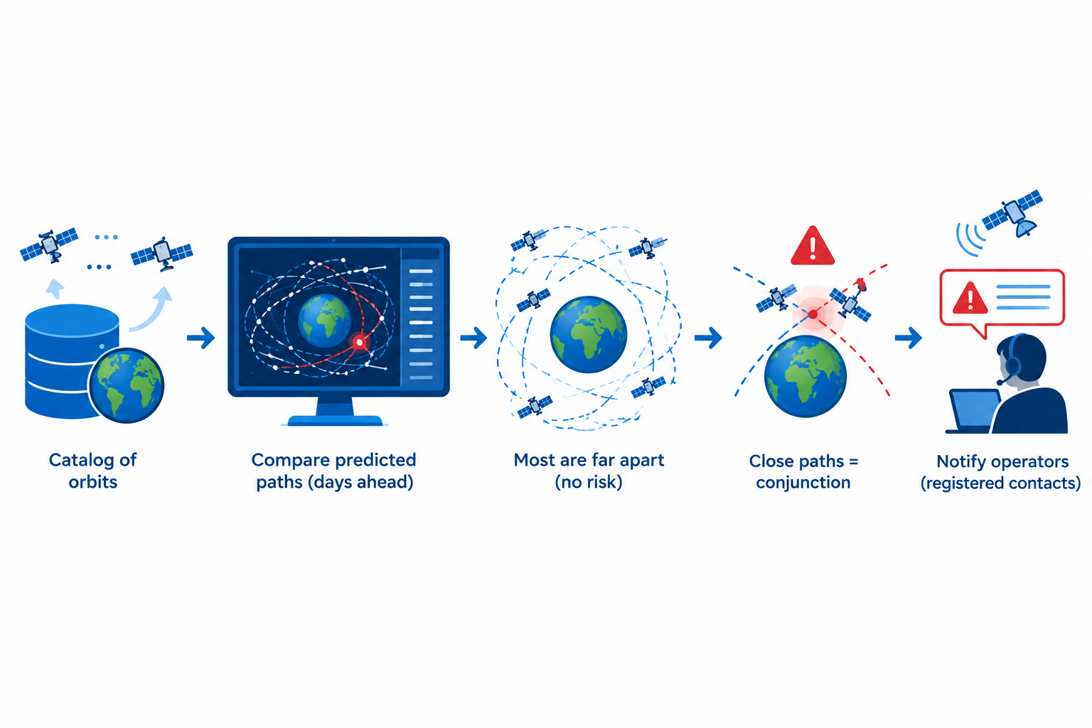
Once an object's orbit is independently confirmed this way, that information does not just sit with whoever tracked it. It gets added to a running global catalog, essentially a constantly updated address book for everything currently in space. The United States Space Command maintains the most widely used version of this catalog through its Space-Track system, publicly accessible at space-track.org, and it is refreshed continuously as new detections come in from radar stations and telescopes around the world.
Each entry in the catalog is not a fixed address, since nothing in orbit stays still. Instead it is closer to a formula, a description of the orbit that can be used to calculate where that object should be at any future time. Every time a fresh detection comes in, the formula for that object gets corrected slightly, because small errors build up quickly at orbital speeds. Keeping this catalog current is a full time operation and it is what makes the next step, comparing every object's predicted path against every other object's predicted path, possible at all.
How to Predict a Collision Before It Happens
With a catalog of orbits in hand, it becomes possible to look ahead, which is something no single detection could ever do on its own. Specialised tracking software, operated by agencies such as the United States Space Force's space surveillance network, takes every tracked object's predicted path and compares it against every other object's predicted path, days into the future. Across tens of thousands of objects, this produces an enormous number of comparisons, run continuously as new tracking data arrives.
Most of these comparisons turn up nothing worth mentioning. This is partly by design, since operators generally choose orbits with enough separation from existing traffic and partly because orbit itself is a genuinely vast space, one where even a crowded region still leaves enormous distances between most objects. But occasionally two predicted paths come close enough that a collision becomes a real possibility. When that happens, it is called a conjunction and it triggers a warning. That warning goes to satellite operators who are expected to register their spacecraft and provide contact details to tracking authorities such as Space-Track, precisely so that if a conjunction involving their satellite is detected, someone knows exactly who to notify and how quickly.
Conjunction as a Probability
It would be convenient if a conjunction warning simply said yes or no, collision or no collision. It never does and the reason comes back to something already touched on earlier, the process of tracking an object is never perfectly precise. Every predicted position comes with a margin of uncertainty around it, a small region of possible locations rather than one exact point. This uncertainty comes from several sources at once. Sensor measurements have their own limits of precision. The exact strength of atmospheric drag on a given day is difficult to know in advance, since it depends partly on solar activity, as covered in earlier articles on this site. Small gravitational pulls from the sun and moon also nudge an orbit slightly away from where a simple calculation would place it. All of these small uncertainties combine and grow larger the further into the future a position is predicted.
When the uncertainty region around one object overlaps with the uncertainty region around another, the result is expressed as a probability of collision, a number describing how likely an actual impact is, not a guarantee that one will happen. A probability of one in ten thousand is treated very differently from one in ten million, even though both technically describe the same kind of event, a possible meeting between two objects moving at orbital speed.
The Manoeuvre Decision
Most active satellites carry small thrusters, engines built not to launch the satellite but to make minor adjustments to its orbit once it is already in space. These same thrusters are the tool used to dodge a possible collision, when a conjunction warning crosses a level of concern worth acting on.
This is where the human decision comes in and in most cases it is a genuine trade off reviewed by a person rather than an automatic reaction. Firing thrusters to dodge a possible collision uses fuel, and fuel is one of the most limited resources on any satellite, since it directly determines how long that satellite can stay operational. Move too often, chasing every low probability warning and a satellite burns through its working life years early. Move too rarely and the risk of an actual, catastrophic collision starts to grow.
Operators handle this trade off by setting a threshold, a probability level above which a manoeuvre becomes worth the cost. Space agencies commonly use a threshold in the range of about one in ten thousand, though the exact figure varies by operator and by how much is at stake if a given collision did occur. Below that threshold, operators simply keep watching as new tracking data comes in, since fresh detections often shrink the uncertainty region and let the probability drop back down on its own without anyone needing to act. Above that threshold, an operator commands the satellite to fire its thrusters and shift its orbit slightly, waits for the danger to pass and then manoeuvres back into position. This decision usually still involves a person reviewing the numbers before any command is sent. This has become such a routine part of operating a satellite in low Earth orbit that it barely makes news anymore, even though it is happening constantly overhead.
The Only Confirmed Satellite Collision in History
On the tenth of February 2009, an active communications satellite called Iridium 33 and a defunct Russian military satellite called Cosmos 2251 collided directly over Siberia. It remains the only confirmed accidental collision between two intact satellites in the history of spaceflight and it produced more than eighteen hundred pieces of trackable debris that are still being monitored today.
At the time, conjunction assessment as described in this article existed, but it was far less mature and far less consistently applied than it is now. Cosmos 2251 had been dead for over a decade, meaning it no longer had any functioning thrusters and could not have manoeuvred out of the way even if a warning had reached anyone. Iridium 33, on the other hand, was still active and did have the ability to move, the same way described earlier in this article, but its orbit was not being watched with the same attention given to other active satellites, so no usable warning reached its operators in time for that capability to matter.
The event became a turning point for the entire field, pushing operators and tracking agencies toward the more disciplined, continuously running system described above, one built to monitor active satellites and debris together, watching for the possibility of a collision between two active satellites, between an active satellite and a piece of debris and even, though little can be done once it happens, between two pieces of debris themselves. It exists specifically so that a quiet, dead object drifting on an old orbit never again gets to collide with something still doing its job.